The Paintings of James McNeill Whistler
M.0030
Map of the North-East States of America
Date
Map of the North-East States of America dates from between 1849 and 1851.
Map of the North-East States of America, Library of Congress
It is catalogued in MacDonald 1995 (cat. rais.) [more] (cat. no. 30); the information on provenance, in particular, has been revised.
Images
Map of the North-East States of America, Library of Congress
Subject
Site
Map of the North-East States of America, Library of Congress
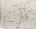
The map shows the north-east states of America, with Lake Erie, Niagara Falls and Lake Ontario at upper left, Maine at upper right, and New Jersey at the bottom. The names of States, some towns, and mountains are given. Several sailing ships decorate the sea, and one, at far right, is labelled 'To Liverpool.'
Technique
Technique
The drawing was done in both back and brown ink, with a very fine pen nib, and probably during more than one class.
Conservation History
The paper is discoloured, and there are cracks at upper left, and some paper loss at lower left.
History
Provenance
- 1849/1851: given by Whistler to Anna Bowers (later Mrs Joseph D. Caverly) (1832-1911), Pomfret, CT;
- Date unknown: given by Mrs Caverly to Annie R. Chilson;
- 1932: given by Annie R. Chilson to a friend on 28 March 1932.
- Date unknown: acquired for the Pennell-Whistler Collection, Library of Congress.
There is no record of the acquisition of this drawing in the Library of Congress. It is not certain that it was donated by Elizabeth Robins Pennell (1855-1936), although that is quite possible.
Exhibitions
Not exhibited in Whistler's lifetime.
Bibliography
Catalogues Raisonnés
- MacDonald, Margaret F., James McNeill Whistler. Drawings, Pastels and Watercolours. A Catalogue Raisonné, New Haven and London, 1995 (cat. no. 30) as 'Map of the North-East States of America'.
Websites
- Library of Congress website at http://www.loc.gov/pictures/item/89709198.